


The Future of Innovation Discovery
From Walking the Halls to AI-Powered Navigation

Searching the Planet: From Google Earth to Google Maps
In 2004, before it had fully entered the lexicon as a verb, Google released two products that changed the way we experience the world. The first, Gmail, redefined email. Today it’s used by more than a billion people every day. The second, Google Earth, reframed how we perceive the planet. Its user base today is a tiny fraction of Gmail’s, but if you measure it by what it enabled, its impact may be even greater.
Self-consciously referencing the iconic all-in-one image of Earth from Apollo 17, Google Earth launched with a beautiful, browser-based image of its own. But unlike its referent, Google Earth was in 3D. I remember it well: with the pull of a mouse, I could spin the globe like the one in my best friend’s bedroom. But unlike that globe, I could zoom in and out to see real satellite images - stitched together into a sprawling, if slightly uneven, digital tapestry. From the pale brown dunes where I was raised to the vast Sahara, I could explore it all from a desktop screen.
From my first hour with Google Earth, I could see a future of expanding use cases: scouting canoe trips and outdoor excursions, modeling new buildings in real cities, tracing river paths from thousands of miles away. As its resolution, algorithms, and data layers deepened, the experience became even more immersive. Before long, I could see the trees in my parents’ front yard, pan around cities and forests, and make otherwise impossible observations - as if floating overhead in a hot air balloon.
Fast forward to today. The last time I used Google Earth was two years ago, planning an elk hunting trip. Before that, I can’t recall. The very qualities that made Earth so enchanting—its planet-wide scope, its pan-and-zoom freedom, its open-ended design—are also what limit its day-to-day usefulness. For most users, Google Earth is still a digital playground.
A year later, Google released Maps. Built on Earth’s foundation, it added three key technologies: GPS, the touchscreen, and wireless data. Together, they allowed users to pinpoint their location on the Google Earth substrate in real time. Suddenly, Maps could solve a concrete, universal problem: How do I get from where I am to where I want to go? Where Earth was powerful, feature-heavy, and exploratory, Maps was streamlined, accessible, and task-specific. That’s why you probably haven’t opened Google Earth in years, but rely on a Maps app every day.
What enabled that pivot was a simple but powerful reframing - from a problem of Landscaping to a problem of Navigation.
Searching for Innovation: Legacy Approaches
This same transition—from Landscaping to Navigation—offers a useful lens for what I call the problem of Innovation Search. Innovation Search refers to the work of investors, startup CEOs, industry scouts, and university specialists tasked with identifying, supporting, and connecting breakthrough ideas from the “Aha” moment in the lab to Series A or strategic partnership. Historically, these searchers have relied on three main strategies:
Walking the halls: the shoe-leather approach. Whether it’s pacing the corridors of a university or the aisles of a conference, this method will always have value. But it’s hard to scale, geographically limited, narrow in aperture, and dependent on luck. “I made a lot of great connections! But what am I missing?!”
Phoning a friend: the method of the well-networked: seasoned VCs, serial entrepreneurs, and the like. Fast and efficient in stable times, but riddled with blind spots during periods of change. It’s also vulnerable to availability bias, groupthink, and insider-outsider dynamics. “I know what my trusted network thinks. But do I know their blind spots?”
Manual mapping: the brute-force method. Whether built by analysts, consultants, or KOL teams, custom ecosystem maps can be elegant - but they’re expensive, time-consuming, and quickly out of date. They also suffer from the burden-of-knowledge problem. Like a McKinsey deck, they’re often admired but rarely used. “This landscape map is beautiful! But how do I act on it?!”
Searching for Innovation: A 2025 Approach
Three years ago, we began exploring a fourth path. Our early work focused on building stitched-together, computational maps of innovation - maps that enabled big-picture landscaping, open-ended search, and zoom-in/zoom-out exploration. We called them Starcharts. These maps revealed insights otherwise invisible: a researcher entering a translational phase, a rising star innovator, a new technology cluster, the shifting structure of a region’s innovation network. Like Google Earth, Starcharts are powerful because they’re flexible. But for the everyday innovation searcher - looking for a startup, a KOL, an investor, or a partner - a more targeted, action-oriented interface is needed.
Enter Stargaze Network, a suite of navigation tools built on top of Stargaze’s computational infrastructure. Like Google Maps, Stargaze Network:
Builds on a rich, multi-dimensional data landscape
Pinpoints your position on that landscape
Shows your “innovation neighborhood”: startups, innovators, funders, and collaborators nearby in knowledge space
Intelligently routes you toward your goals: new partners, funding opportunities, or breakthrough connections
Improves with every user and updates as the landscape changes
Here’s how Stargaze Network works:
1. MY LOCATION
First, Stargaze Network finds your location on the map. It does this using a short series of prompts on your Company Profile: How would you describe your company’s core technology? What are you working on? Are there any papers that are foundational to your venture? From your answers, Stargaze triangulates your location on our Innovation Hypergraph, much like a GPS.
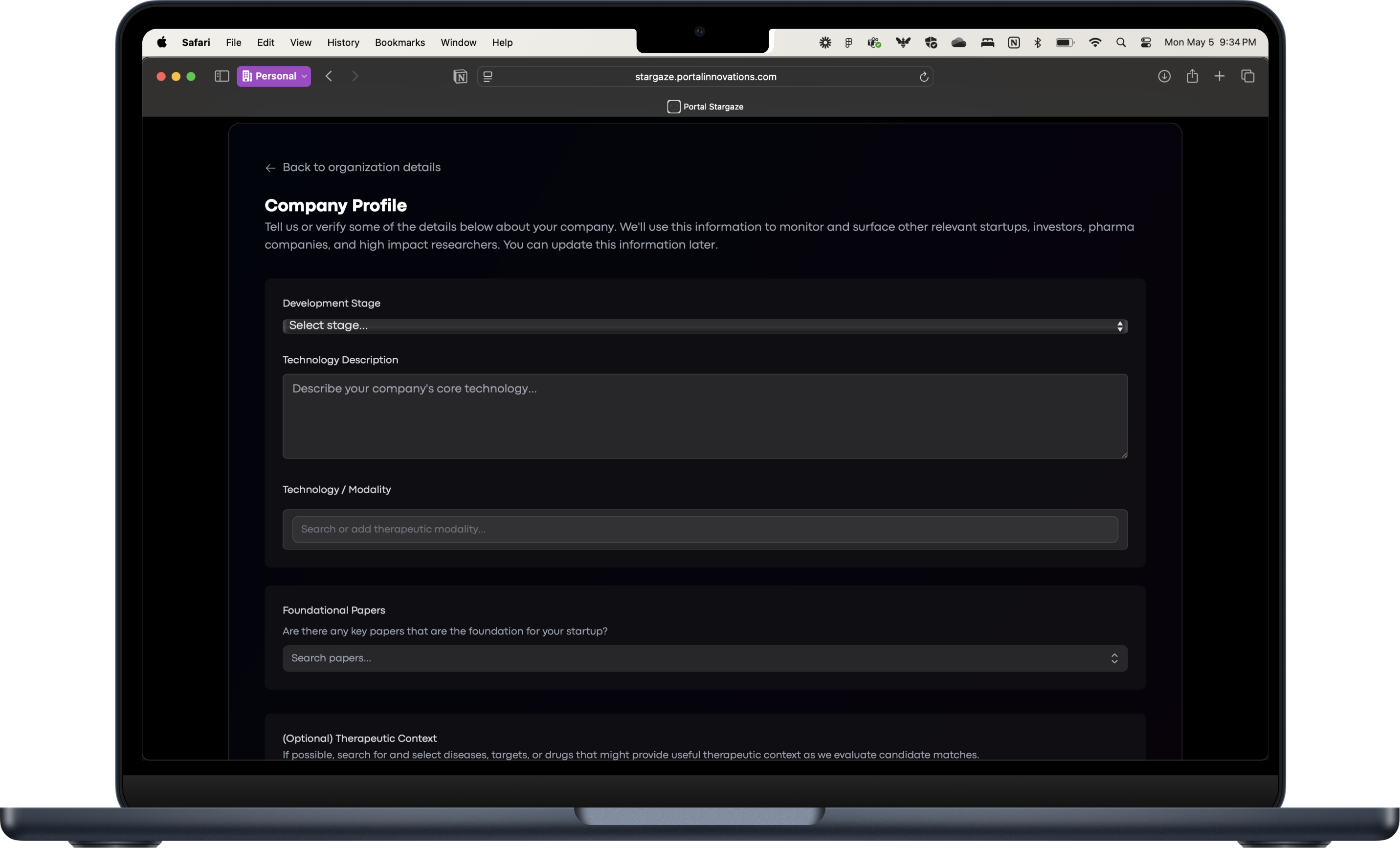
By default, your location (but not your private information) is visible to others. For example, if you’re a startup, your name and publicly available information are visible to VCs or industry scouts who may be exploring that region of the map. As the network grows, we plan to support double-opt-in connections (e.g., “Steve at Portal Innovations would like to view your profile and connect. Interested? Click accept and share.”)
2. MY NEIGHBORHOOD
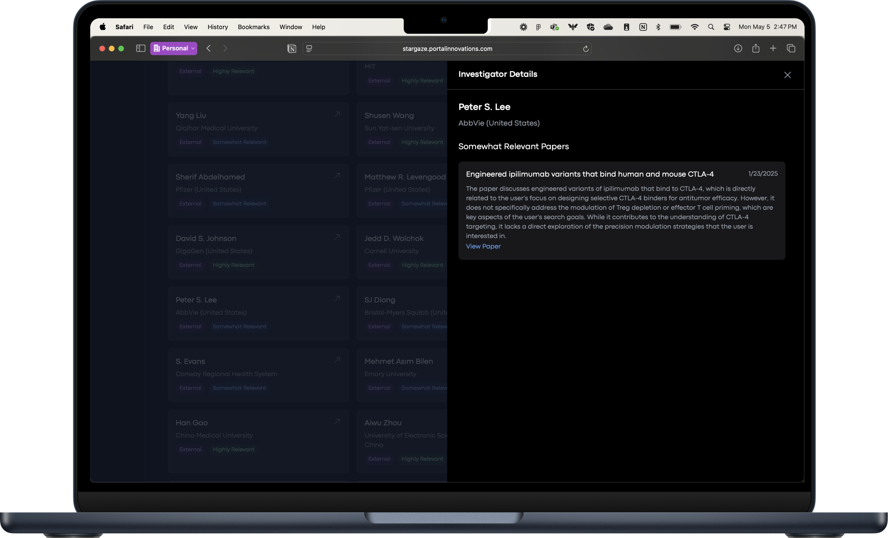
With your location resolved, Stargaze expands a bubble outward to identify your “Innovation Neighborhood” - the most relevant startups, people, and papers occupying the surrounding knowledge space. This is one of the most immediate and compelling features of Stargaze Network.
We’re making a basic version of Neighborhood available to everyone who signs up. Additional features—richer datasets, more powerful models, and expanded neighbor types (investors, pharma, funders, etc.) - are available to Portal Member companies and enterprise partners.
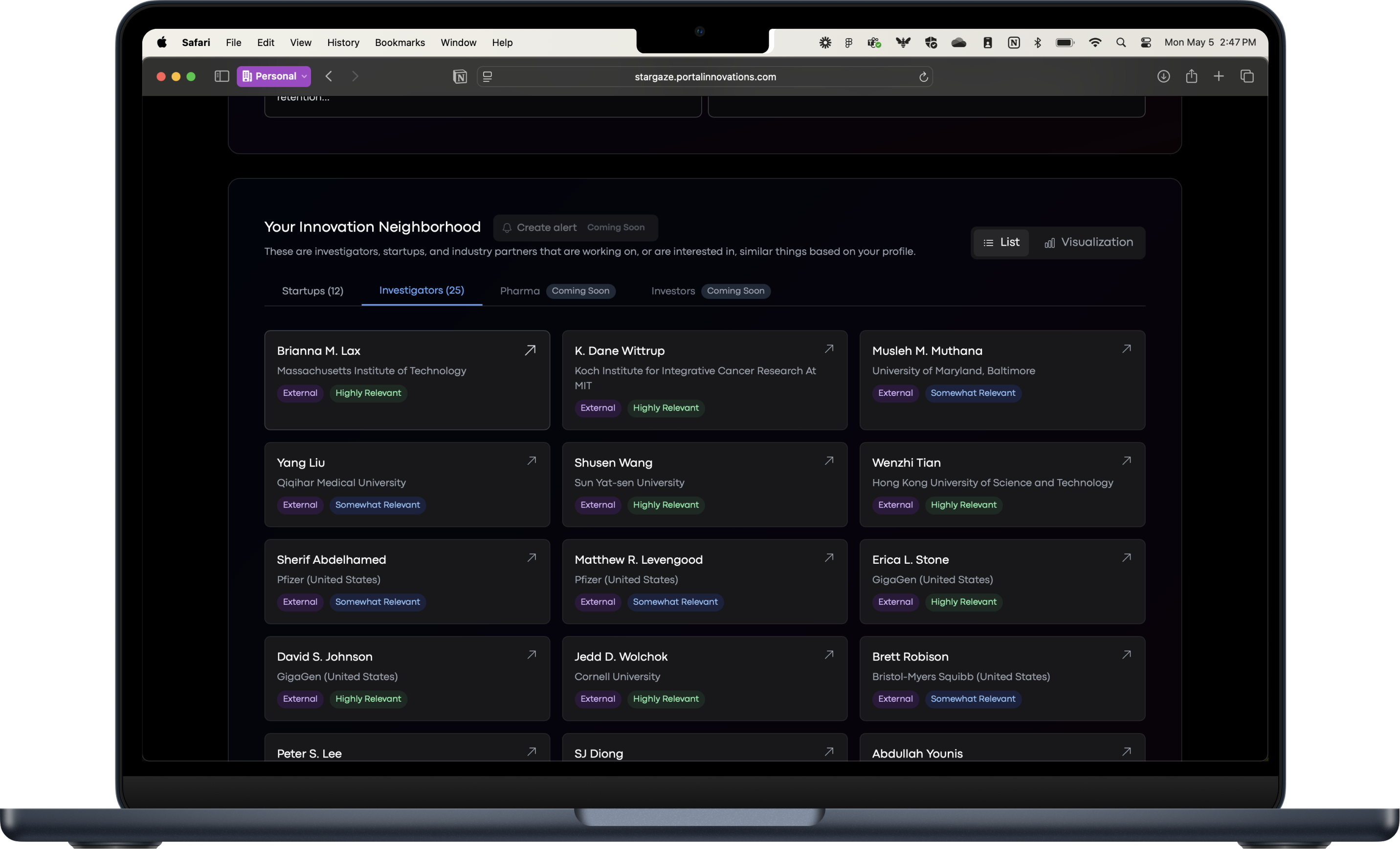
A few additional notes about Innovation Neighborhoods:
They update automatically. Depending on your user level (free, member, enterprise…), Stargaze refreshes your neighborhood on a weekly, monthly, or quarterly cadence.
Every neighbor comes with a plain-language reason for inclusion. Want to know why someone showed up? Stargaze explains the connection.
3. NAVIGATOR
Navigator takes you beyond your current position; it helps you chart a course to where you want to go. This may be the most powerful feature of Stargaze Network.
Much like the find-your-location process in Neighborhood, Navigator uses a combination of text input, drop-down ontologies, and seed papers to anchor your query in the Innovation Hypergraph. From there, it expands outward through a combination of:
Agentic search: iteratively refining your query to explore multiple angles
Context-driven citation expansion: growing from a core set of papers, pruning irrelevant branches, and revealing only what matters
It’s like typing “Edinburgh, Scotland” into Google Maps and getting the full local landscape - streets, shops, restaurants, context. But Navigator goes a step further: it evaluates your map and generates a prioritized list of the most relevant people, startups, papers - and for advanced users, investors, funders, and pharma partners.
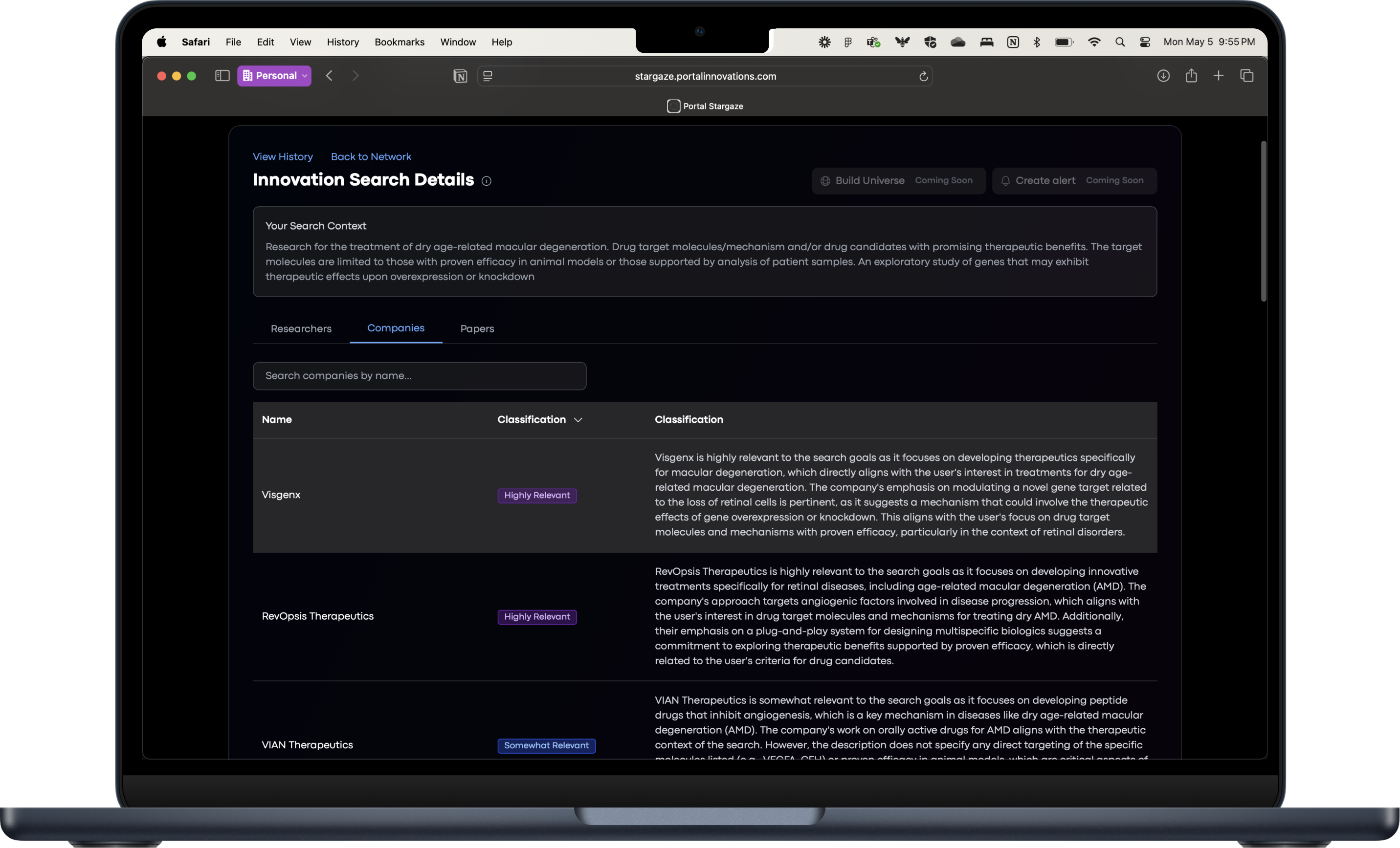
At the free tier, Navigator is great for helping:
Find KOLs in niche or cross-disciplinary fields
Identify under-the-radar researchers
Spot new indications or applications for your tech
Premium tiers enable you to:
Find investors aligned with your technology’s topic or adjacent domains
Locate strategic partners in pharma, diagnostics, or tools
Match extramural funding opportunities with the best scientific talent in your organization
…and more
CONCLUSION: FROM MAPS TO MOVEMENT
The technical infrastructure we’ve built - Location, Neighborhood, Navigator - forms the basis for a broader set of tools. These modules are designed to support the full arc of innovation search, from early signals of translational potential to downstream alignment with funders, partners, and markets. Some are already live. Others are in development. Together, they enable a shift from static maps to adaptive tools - tools that help innovation searchers act, not just observe. Because innovation no longer lives in a fixed landscape. It moves. It clusters, fragments, and re-forms. It demands tools that can keep pace.
If you’re ready to stop wandering - and start navigating - we invite you to sign up for Stargaze Network. Find your location and start finding your way forward.